O FGIS continua a ser um dos software GIS mais usado na área florestal, em empresas de pequeno porte e produtores independentes, para auxiliar quando o assunto é geoprocessamento e informação geográfica. Muitos continuam a utilizar o AutoCAD, porém como este não é um GIS em essência, muitos optam por usar um GIS real, principalmente nos EUA.
Não deixem de conferir essa poderosa ferramenta, você não vai se arrepender:
Mais, do fabricante:
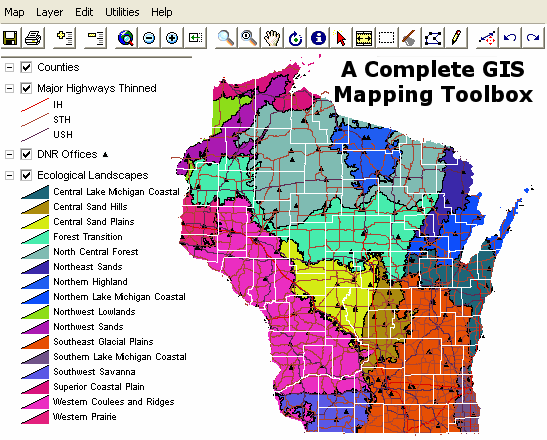
fGIS™ is a remarkable, free GIS digitizer and shapefile editing program and GIS viewer for Windows® from the University of Wisconsin and Wisconsin DNR – Division of Forestry. It provides complete mapping functionality similar to commercial programs costing hundreds or thousands of dollars. The software is designed for resource managers who want to easily make land planning and operations maps with minimal training. The program is ideal for tracing over aerial photographs and other images. fGIS opens geo-referenced digital orthophotos and topographic maps in MrSID®, ECW, BIL, JPG, TIFF, GeoTIFF, BMP and PNG file formats. It saves point, line and area vector data in ESRI® shapefile format. Advanced map drawing features include snap, split and a COGO-like traverse tool. A shapefile projection utility within fGIS converts data between Geographic, Wisconsin Transverse Mercator, and UTM coordinate systems. The program can load very large data layers and gives complete control over display properties. Users can designate the scale at which maps are printed. A page layout module provides design and annotation tools that can be applied to fGIS map images.
O figura..
Como seu usa esse software FGIS.
Você tem alguma apostila, dica, tutorial.
Agraço.
Cid